Barnet has two key planning documents that deal with the Boroughs archaeology. It has the Local Plan Core Strategy and the more detailed Development Management Policies. Both these documents were approved by Council in 2012 following an examination in public, to which HADAS contributed. What do these documents say and how can we use them to further the interests of Archaeology in Barnet?
The core strategy has warm words to say about Heritage in Barnet noting that the borough has a broad range of ‘heritage assets’ including Conservation Areas, Listed Buildings, Registered Historic Parks and Gardens, Locally Listed Buildings, Scheduled Ancient Monuments, a Historic Battlefield site and Local Areas of Archaeological Significance. These assets “can be used to ensure continued sustainability of an area and promote a sense of place.”
The Core Strategy notes that Barnet has a “rich archaeological and architectural heritage which includes the only Historic Battlefield (Battle of Barnet – 1471) in London.” In addition, there are “nearly forty sites of archaeological importance containing prehistoric, Roman and medieval remains.” In terms of buildings of historic and architectural importance in Barnet there are over 2,200 Listed Buildings and 1,600 buildings on the Local List. (The Local List is under review – see the article by Vicky) There are “two Scheduled Ancient Monuments at Brockley Hill in Edgware and Manor House in Finchley, three registered Historic Parks and Gardens at St Marylebone Cemetery, Avenue House Garden and Golders Green Crematorium.”
The Core Strategy notes that Barnet’s archaeological heritage is a “valuable education and community resource. As Barnet changes it is important that development proposals in areas of archaeological significance help broaden our knowledge of the past as a result of properly conducted on-site investigations.” It all sounds promising. The detailed policies are contained in a separate document known as the Development Management policies and DMO6 – Barnet’s Heritage and Conservation is the one to watch. (Copy of this policy at end of this piece.) The preamble to the policy comments that archaeology is “vulnerable to modern development and land use. Archaeological remains above and below ground level, and ancient monuments, are important surviving evidence of the borough’s past, and once removed they are lost forever.”
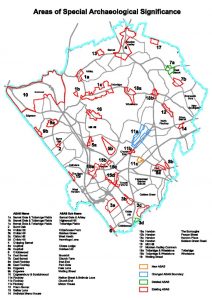
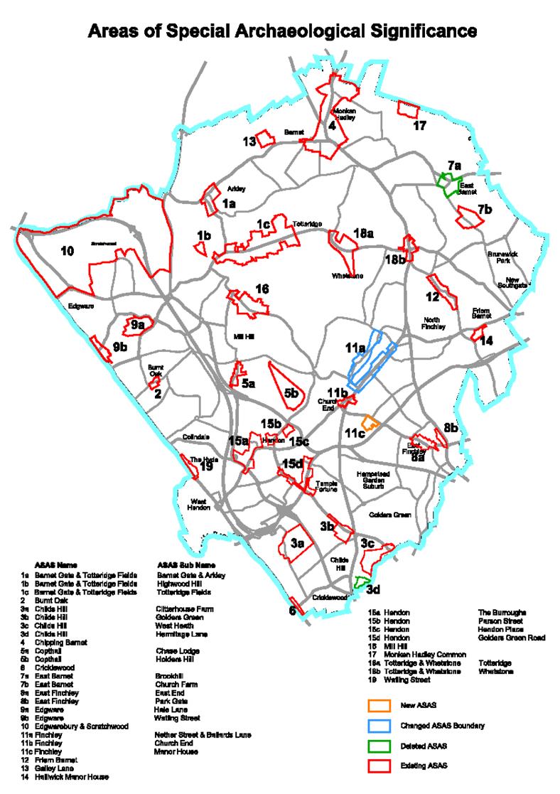
Barnet with assistance from English Heritage (via the Greater London Archaeology Advisory Service – GLAAS), the Museum of London and the Hendon and District Archaeological Society (HADAS), has identified five prehistoric, four Roman and thirty medieval sites containing archaeological remains of more than local importance. These have been grouped into nineteen ‘Local Areas of Special Archaeological Significance’. (See map below)
Development proposals in these areas will need to provide detail in consultation with GLAAS of how they will investigate, catalogue and where possible preserve the remains in situ or in a museum as part of any application. It may also be appropriate for HADAS to be consulted.
Barnet accept that “discovery is an important basis of archaeology.” They continue that “when researching the development potential of a site, developers should, in all cases, assess whether the site is known or is likely to contain archaeological remains. Where there is good reason to believe that there are remains of archaeological importance on a site, we will consider directing applicants to supply further details of proposed developments, including the results of an archaeological desk-based assessment and field evaluation.”
Barnet further remark, “where important archaeological remains are found the council will seek to resist development which adversely affects the process of preserving the remains on site. Where this is not possible mitigation which may include excavation, analysis of remains and public dissemination of results will be expected by an archaeological organisation with approval from the GLAAS and the council before development commences. If permitted, the loss through development of any archaeological remains will need to be recorded in line with para 141 in the NPPF. (National Planning Policy Framework) Planning conditions or a legal agreement will be used to secure this.
Overall the Framework for considering Archaeology in Barnet appears strong. The practical application of the policy by the planning department does not always appear to fully reflect the fine words. Sterling work by HADAS members tries to keep the archaeology banner flying high.
Over the years many developers in Barnet have submitted desk top appraisals on sites prior to development and some field reports have been completed. Using these, along with site visits, historical research etc. I’m proposing that we establish a HADAS Research Group to start in the autumn, on Sunday mornings at Stephens House, with the intention of reviewing all 19 of the Boroughs “Local Areas of Special Archaeological Significance”. Partly this will be so that we can proactively identify sites where we know in advance that we will want detailed archaeological work to be undertaken but also to prepare ourselves for the update of Barnet’s planning policies which will begin in the next 18 months or so and to which we can put detailed evidence of existing areas and possibly also identify new ones for inclusion.
Interested in getting involved in this research? Email me at the following address: roger.chapman99@btinternet.com
PS There are plenty of acronyms and jargon used in the planning process and as a practicing planner of over 40 years I may have fallen into the trap of using too much of it above. If you join the Research group I’ll let you into the secret of why planners use so much jargon. In the meantime you should get to know one more term because Historic England have determined that all Boroughs across London should now call their defined Areas not as “Local Areas of Special Archaeological Significance” but as “Archaeological Priority Areas.”
| Policy DM06: Barnet’s heritage and conservation |
| a. All heritage assets will be protected in line with their significance. All development will have regard to the local historic context. |
| b. Development proposals must preserve or enhance the character and appearance of 16 Conservation Areas in Barnet. |
| c. Proposals involving or affecting Barnet’s heritage assets set out in Table 7.2 should demonstrate the following: |
| • the significance of the heritage asset |
| • the impact of the proposal on the significance of the heritage asset |
| • the impact of the proposal on the setting of the heritage asset |
| • how the significance and/or setting of a heritage asset can be better revealed |
| • the opportunities to mitigate or adapt to climate change |
| • how the benefits outweigh any harm caused to the heritage asset. |
| d. There will be a presumption in favour of retaining all 1,600 Locally Listed Buildings in Barnet and any buildings which makes a positive contribution to the character or appearance of the 16 Conservation Areas. |
| e. Archaeological remains will be protected in particular in the 19 identified Local Areas of Special Archaeological Significance and elsewhere in Barnet. Any development that may affect archaeological remains will need to demonstrate the likely impact upon the remains and the proposed mitigation to reduce that impact. |


