No. 494 MAY 2012 Edited by Sue Willetts
HADAS DIARY — Forthcoming Lectures and Events
Lectures are held at Avenue House, 17 East End Road, Fi nchley, N3 3QE and start promptly at 8.00 pm with coffee /tea and biscuits afterwards. Non-members welcome (£1.00) Buses 82, 125, 143, 326 & 460 pass nearby and Finchley Central Station (Northern line) is a short walk away.
Tuesday 8th May 2012. – Bumps, Bombs and Birds: the history and archaeology of RSPB reserves. Lecture by Robin Standring who is Reserves Archaeologist at the Royal Society for the Protection of Birds (RSPB) covering their reserves network, some 150,000 hectares of wild and beautiful countryside spread the length and breadth of the UK. With a background in field archaeology and a life-long interest in conservation, Robin is the first full time archaeologist employed by the RSPB, joining in 2009 with grant assistance from English Heritage.
There are some 200 RSPB nature reserves, and whilst these are known to be rich in wildlife, it is less well known that there are also many thousands of archaeological sites and features. Key highlights of the collection include almost 200 Scheduled Ancient monuments and one of the best collections of both prehistoric and military archaeology of any single land manager. Robin’s work has focused on ensuring the sympathetic management of these sites as well as making them more accessible and interpreted for visitors. The RSPB is also engaged in ambitious programmes of wetland and heathland habitat restoration and he is trialing methods to ensure that minimum impacts are made upon archaeological remains.
Thurs. 10th May Quiz at Avenue House
Tues 12th June 2012 – Annual General Meeting at Avenue House.
Sun 26th — Thur 30th August 2012 – Summer trip to Ironbridge.
Tues 9th October 2012 – The Life and Legacy of George Peabody. Lecture by Christine Wagg Tues 13th November 2012 – Archaeological discoveries in Southwark. Lecture by Peter Moore, Pre-Construct Archaeology (PCA)
Sun 2nd December 2012 — Christmas Party at Avenue House from 12 noon – 4.30 (approx) LAMAS 49th Annual Conference: Museum of London — 24th Mar 2012.
Andy Simpson. An excellent and informative conference, as always … and very well attended.
Morning Session: Recent Work
Guy Thompson from PCA in his talk entitled ‘An immense and exceedingly commodious goods station’ to quote a contemporary source, examined the archaeology of the Great Northern Railway goods yard at York Way, King’s Cross, dating to 1850-51, with its former mass of sidings industrial character and surviving buildings, tracks and wagon turntables, currently in part being restored for use as part of a University campus. Features studied since 2007, as the pace of redevelopment of the area increased, included subterranean stables.
Malcolm McKenzie from MoLA described the fascinating archaeology of the northern-side Thames waterfront at Three Quays House, Lower Thames Street, west of the Tower of London. Demolition of a long-derelict post-war office block involved the hand excavation of some 40 pile shafts each some 2m square over a ten-month period. Extensive and well-preserved remains of a second-third century Roman timber quay were found, with some
massive timbers surviving, some of them re-used architectural timbers of first century date; plus a huge deposit of unabraded Central Gaulish Samian, clearly deposited as a single (unknown) event, and in two or three shaft bases, the very denuded footings of the third century masonry riverside wall.
A medieval phase of medieval timber quay, south of the Roman quayside line, included more well-preserved timbers; some of them re-used boat timbers and sections of boat, hardly surprising since in medieval times this area was known for its shipbuilding. Contemporary with this was a huge quantity of metal-detected small finds, including buckles and pilgrim badges.
Joanna Taylor’s talk ‘The Thameslink Project in North Southwark: Recent work’ covered the detailed Network-Rail funded work by Oxford Archaeology/Pre-Construct Archaeology in advance of extensive redevelopment of the area. Work on the new Thameslink Borough viaduct has given further insights into building complexes in Roman Southwark, an area of islands and marshes/mudflats amidst the Thames in Roman times. The well-known Wheatsheaf pub site continued work by MoLA, with four metres of good quality archaeological deposits in the back yard/garden of the pub, eighteenth-century brick pub features and with finds-rich medieval cesspits cutting the Roman levels which included truncated masonry foundations.
A nearby site – Bedale St – involved the demolition of three properties (which will be rebuilt after completion of the viaduct) which sealed two metres of deposits – medieval soils and virtually no Roman levels remaining. The major feature was a large seven metre-wide ditch with evidence of a wooden fence that had collapsed into it. This feature was undated, but was post late-Roman and predates the 12th / 13th century. Perhaps this is a late Saxon ditch defining the Saxon Southwark bridgehead settlement.
Further work at 11-15 Borough High St (on the corner of London Bridge St) had high archaeological potential, being adjacent to the Roman road to the northern Southwark island. Modern basements had left islands of good archaeology, including a Roman masonry building with flooring intact and traces of underfloor heating and post-Roman robber cuts. The new building was redesigned to preserve as much as possible in the centre of the site. It is being interpreted as a bathhouse; its exact function is unknown, but it included a 5.75m diameter circular room and limescale accumulations on the floor, supporting this interpretation. Also found were substantial medieval stone foundations interpreted as part of St Thomas’s hospital. For more details see: http://www.thameslinkprogramme.co.uk/news/news items/view/106
John Shepherd in his talk ‘The Temple of Mithras 1954-2012: There and back again’ looked at recent work on the moving, further excavation, and re-interpretation of the famous Temple of M ithras, shortly to be moved back much closer to its original find spot and reconstructed in a much more sympathetic and architecturally correct manner than its crazy-paving floored open-air incarnation of the last 40 years in Queen Victoria St. The new indoors display will form a major part of the new development of the site, with dedicated entrance, interpretative area above to include the original and more recent excavation and general archaeology of the area, and temple display below in an enclosed space to reflect the feel of the temple when first built.
As is well known, the temple was first dug in September/October 1954 on the later site of Bucklersbury House. The temple was built in the 240s AD and converted to a temple for the cult of Bacchus in the fourth century. After public outcry ensured its ‘preservation’ in 1954, the footings of the temple – or rather, as it transpires from recent excavation on the site, most of them – were rather roughly dismantled and stored in roughly the right shape in a bomb-site cellar, quickly becoming disturbed and overgrown. A later move took them to Harrow prior to ‘reconstruction’ on the wrong site and with the wrong orientation. Much original material was lost and replaced with modern concrete, which was carefully removed during the most recent dismantling. Recent excavation on the original site has revealed in-site temple foundations, including mote of a front narthex entrance building, and good organic preservation. Careful plotting of remaining bombed Victorian cellar walls and other features permitted the original site and orientation to be located.
Afternoon Session: Roman Greater London
Isobel Thompson looked at ‘Putting the foundation of Londinium in context – the view from the North’. Looking at the foundation of Londinium based on the Hertfordshire Historic Environment Record (H ER), which indicates over 320 late Iron Age sites in Hertfordshire alone, with plotted settlement/find spots indicating distinct Iron Age styles of pottery divided by a distinct gap formed by the Roding Valley in Essex.
Our old friend (and President) Harvey Sheldon looked at ‘The Roman Pottery Manufacturing Site in Highgate Wood: Archaeology and Experiment’. Nearby Roman roads included Ermine St through Enfield and the suggested V iatores Route 167 through Mill Hill. Highgate is an ancient wood with oak and hornbeam. Ownership of the site passed to the Bishop of London in the seventh century; prior to that it was owned by the Kings of Essex, and may even have been part of the public land administered by the former Roman authority governing Londinium. In 1886 it passed to the Corporation of London for preservation as public open space following a vigorous campaign by those concerned it would be lost to rapidly spreading Victorian suburban development. There are undated banks and ditches in the wood. A 1960s survey looking for flints found first/second century Roman pottery such as poppy-head decoration beakers as well as Mesolithic flints, with a campaign of digging from 1966.
Kilns, kiln dumps/waster mounds and rough flooring were found, along with a series of ditches; kilns excavated had pedestals, walls and flues; one kiln, now removed and preserved off-site, had a tile-covered flue, this being the last kiln found. Some pots were found near-complete, sometimes reused to support flue arches. Fabric was reduced grey, some with grey slip using clay imported from elsewhere. The site appears to have four production phases and three types of fabric (grey/grog /sandy tempered wares), covering the period 50–160+ AD; there is also a surprising amount – some 354 sherds – of Antonine Samian ware dated 70–140+ AD, just as Brockley Hill yielded pottery other than that produced on site.
Martin Dearne kept the hall amused with a highly entertaining and informative review of Roman Enfield: ‘First Stop North of Londinium’. A major feature at the north end of this site on Ermine St. was a possible Mansio. This small roadside settlement, lying mostly on the western side of Ermine St, has mainly been investigated by the Enfield Archaeological Society, with the first recorded finds during suburban development in 1902: cremation burials at the edge of the settlement. Major study began in the 1960s, with the first proof of actual settlement. Much of the excavation work has been in back gardens, with the settlement site covered by housing and a school. So far, there is nothing of pre-Flavian (70s AD) date other than a ditch, the settlement beginning at the north of the site and expanding southwards from the suggested official Mansio/ Mutatio, with the settlement at its zenith in the second century. There is little evidence of great wealth or prosperity, but some glass from a cremation burial, and occupation continues into the late Roman period, late 4th/early 5th century, with one possible fifth-century military/civil service style belt fitting. The settlement lies in an overall landscape, with burials and possible villa sites to the west, possibly along with a tannery; recent discoveries – naturally found after the reconstruction painting shown at last year’s Roman Enfield exhibition was produced – are two southern E-W boundary ditches parallel to a small stream, perhaps reflecting an attempt to impress and showing civic pride, the ditch later replaced by a bank.
Alistair Douglas of PCA studied ‘The Enigma of Roman Shadwell’, the site lying on a gravel river terrace 1.25km east of Londinium, beyond the eastern cemetery, north of what in Roman times was Wapping Island in the Thames. In the 1970s, a robbed square masonry foundation was excavated, 5m square internally, interpreted at the time as a watch tower or signal station, though as Douglas pointed out, a better location for such would surely have been the high ground at Greenwich; it may actually have been a mausoleum, and is dated to the mid-second century. Finds from this dig indicated a large settlement, with Roman levels preserved by deeper soils on a slope, and clay and timber buildings of third/fourth century date, plus wells and two oven-like structures, and timber-lined tanks, possibly for water management-settling tanks?
All Shadwell sites have East Gaulish Samian – the latest of the Samian wares, produced in the Rhine region, perhaps for a site that was officially sponsored, though not necessarily a military one, reaching its peak in the mid-third century.
A further excavation in 2002 on the former Babe Ruth club site in Highway revealed more clay and timber buildings and a well -preserved apsidal bathhouse measuring 19m x 20m, with not all of it exposed. Facing the Thames, and with 16 rooms, it was the second biggest bathhouse in London after the baths at H uggi n Hill, and was of third century date, remaining in use for a century or more.
This seems to have had a communal use, suggested by remains of snacks including chicken bones, along with a fourth-century gold ear ring and gold bracelet, and also along with, according to the accompanying reconstruction drawings, other typical Roman bathhouse pursuits of carousing and indulgence in more earthy pastimes suggested by the presence of female accoutrements such as hairpins, finger rings and bracelets. In addition to the bathhouse and an associated clay and timber building, there was a boundary ditch and the previously recorded ‘tower’ building. The four sites excavated in the immediate area have yielded 800 coins, suggesting a settlement of roadside settlement/small town size, with good trading links to both Europe and Britannia’s interior via water transport. First/second century Londinium had been a logistics/distribution centre, but by the third/fourth century it was self-sufficient, though with a declining population and long-distance trade decreasing, with trade perhaps moving to the settlements at Old Ford or Shadwell. River levels were dropping, but Shadwell remained a vibrant centre to the mid-fourth century.
Finds in 2010 included a collapsed masonry building, with late Roman coins, and better preservation at the south end of the site, including a further Roman oven and a weathered first-second century altar stone. For general Shadwell background information, see http://www.museumoflondon.org.uk/Explore-online/Pocket-
histories/roman/roman_london_5.htm
http://www.ncl.ac.uk/historical/research/publication/178005 http://www.museumoflondonarchaeology.org.uk/Publications/pubDetails.htm?pid=31
David Bird looked at ‘Recent Excavations at Ashstead villa and tileworks, Surrey, and their implications’. The villa site was dug, in the manner of the time, in 1929, revealing a villa and separate bathhouse and evidence of tile-making. There are few surviving site notes – one sketch being literally on the back of an envelope – plus some contemporary press report. The site report was published promptly, with more work on the site in the 1960s; amateur excavation of this relatively remote site has recently continued for 13 seasons. There is a nearby three-period earthwork, originally prehistoric, with mid-first century and later Roman recutting. The villa has a floor plan seemingly unique in the Western Empire, but recent work has added a proper phasing plan, indicating that the building is not all one phase, revising the ground plan somewhat with differing phases of masonry. One room was lined with box flue tiles – whose overnight vandalism, even in 1929, prompted closure of the excavation. There may be a separate building of Flavian date. Geophysics has been done to find the ti l ery and two tile kilns have been found, one on top of the other. This may reflect this and other villa estates having an associated industry – tile, pottery, or stone working, or even timber cutting.
London’s Foundations Peter Collins
Recently, a report entitled London’s Foundations has been published by the Mayor of London. It can be seen at (http://www.london.gov.uk/publication/londons-foundations-spg). Although this is a planning document about London’s geology, it may be of interest to HADAS members as it highlights sites of geological interest across London, many of which have archaeological or historical associations.
A number of these geological sites are within the HADAS area or its vicinity, including Avenue House. When you visit there you may not realise you are standing on glacial till or boulder clay brought down by the Anglian ice sheet some 450,000 years ago. In the gardens, especially when the soil is disturbed by gardening works, the tell-tale pebbles of chalk can be seen. Nearby Coldfall Wood has similar features. Others sites in the vicinity include the complex of Hampstead Heath and Kenwood House, which is recommended by the London Geodiversity Partnership (LGP), http://www.londongeopartnership.org.uk/ as a geology site of regional importance (RIGS). Within Kenwood there is an abandoned quarry face, for the Bagshot sand and the hillocks of Sandy Heath are the result of similar exploitation. In the Heath, Claygate, the top-most member of the London clay was ideal for brick making and, in the nineteenth century, its extraction resulted in Viaduct pond.
If you have any comments or ideas on interesting geological sites in the HADA S area please contact me below and we can consider them within the LGP. Mobile: 07718 587739
E-mail: peter@collins-at-queenscres.org.uk
New map of Roman London Sue Willetts
On 17.1.2012, Julian Hill (MoLA) gave a lecture at the Museum of London which covered the background to the mapping of Roman London over the centuries — publicity for the new map: Londinium: a new map and guide to Roman London. The talk provided an overview of the history of recording Roman remains, known or otherwise indicated. The map shows public buildings, houses and defences which are shown superimposed on the modern street plan. Areas north and south of the river are shown, as is an indication of how the water levels and shoreline have changed over time. On the reverse and to the sides of the map is a detailed and well illustrated historical overview including 18 sites to visit with visible remains. There is a great deal of information included on this map including suggestions for further reading. The map costs £6.25 ISBN 978-1- 90786-05-7.
HADAS Finds Class Blog Stephen Brunning
Regular readers of this newsletter will no doubt know that HADAS took over the running of the old Post-Excavation Analysis class from Birkbeck College in September 2009 and renamed it “Looking at Finds”. If you wish to find out what we get up to behind the scenes on Wednesday evenings at Avenue House, check out the new blog at: www.hadasfindsgroup.blogspot.com. Please feel free to register as a follower, and/or post any comments you wish.
Crop marks Montrose Playing fields Bill Sibley
Having lived in close proximity to Montrose Playing fields for 70 years I am curious about the development of ‘crop marks’ over the past 3/4 years sited by the security camera near to the sports pavilion. Two large sunken rectangles approx 8 x 12 metres in size are becoming more apparent each year; they can be seen quite clearly on Google maps, just call up ‘The Greenway NW9 5AU@ this will bring you close enough to the location. The ‘sinks’ are similar to wooden beam wall foundations rotting away as when old tree roots rot away leaving ‘indents in the ground’.
From studying some old maps, I know that the footbridge nearby was built on the site of a ‘Ford’ for crossing the Silk stream that runs through the park on its way to the Welsh Harp and that some structure may have been built there in the past (who knows how early). I have spoken to older residents than I, who lived in the area during the war years and they discount air raid shelters as they were built further out in the playing fields which is where I remember them as a child before they were demolished. I am also aware of the tram shed and rail link from the park to Mill Hill Broadway sidings for bricks and supplies to Lai ngs when the housing in the area was developed in the late 20’s/ early 30’s on the site of the old Shoelands Farm land, but this again was further out in the field. Would this be of interest for further investigation either to HADAS members or any archaeology students living locally?
Spoilheap removed ‘by persons unknown’ –
The Fuller Street excavation 1974 Part 1. by Andy Simpson
(Part 2 will be continued in a future newsletter)
Following on from looking at the White Swan 1976 excavation, the author decided to look at another previously unpublished HADAS excavation, this time in central Hendon from 1974 – in fact, it followed on from the highly successful Church Terrace excavation of 1973-74, and was located only a short distance away to the east, but was much less successful.
The Fuller Street Area
The Church End area of central Hendon once featured a densely-packed area of Victorian terraced houses and workshops running down to Sunny Gardens and up to Church Walk, centred around the now lost or re-routed Prince of Wales Road, Heading Street, and Fuller Street.
As shown on the 1895 Ordnance Survey map (and Godfrey Edition of the 1912 OS map), the Victorian Fuller Street ran north-south off Church Lane (now Church Road), opposite Ravenshurst Avenue (where the south-eastern corner of Fuller Street – at NGR TQ 232 895 – had a shop, 48 Church Road, which acted as an outlet for the Express Dairy, College Farm, Finchley), towards Church Walk. Fuller Street was lined with typical (mainly) two-story, side-passage terraced houses of the time, dated around 1869, which had tiny fenced front ‘gardens’, fronting onto the pavement, and long, narrow back yards. At least until Edwardian times Fuller Street houses shared one toilet and a scullery between every two houses. The western side of the road’s houses began beyond Chad’s Alley which divided them from the backs of shops fronting onto Church Road at the corner, where there was also a traditional three-story corner shop (No. 46 Church Road, latterly ‘Weiner’s’ butchers, still standing in 1976 at NGR TQ 242 894), and backed onto the backyards of similar terraced houses in the parallel Heading Street. On the eastern side, the backyards faced out towards a builder’s yard and Sunny Gardens Road.
Luckily, HA DAS record cards with photos record the street and its environs in 1970-71, prior to total demolition.
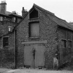
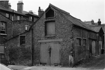
The western row of twelve mainly flat-fronted houses on Fuller St, numbered 2-24, ended in two better quality terraced houses, nos. 2 and 4, with two bay windows flanking a shared entrance with portico-effect pillars. They stood adjacent to Chad’s Alley, running westwards through to Heading Street which also ran north-south off Church Road and was lined with a jumble of two-story brick-built former workshops and stables on its southern side. This southern side backed onto the buildings on Church Road. On the opposite side corner of this alley, also on the southern side, behind 46 Church Road, was a brick-built two-story former slaughterhouse, with roof loft, recorded on 11 December 1971.
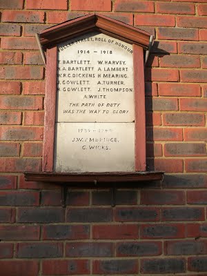
The brick wall across the end of Fuller street at the Church Walk end, as well as having a gate leading to Richards builder’s yard, also mounted Fuller Street’s own tablet-style memorial to the men who died in two world wars, facing down the street; happily this still survives today, mounted on the gable end of a row of houses facing the present Fuller Street. There had been considerable correspondence between HA DAS and Barnet Council concerning finding a new location for it.
By 11 December 1971 the eastern side of Fuller Street, numbered 1-29, was being demolished; it featured at least one once-elegant three-story house with decorative brick banding (Nos. 3 and 5 Fuller Street, part demolished by 11 December 1971), adjacent to a gated entrance, with room above, leading to a small yard used as industrial premises by Express Dairies, and more two-story terraced accommodation next to this (No.1 Fuller St).
The whole area was demolished during clearances in the early 1970s, with the last family to leave Fuller Street being George David ‘Happy’ Bartlett and his wife Edith, the last of seven generations living there. From 1974 on it was replaced with flats fronting Church Road and modern low-rise housing. The original line of the street was lost; there is still a Fuller Street, but it runs at right angles across the original line of the old Fuller Street from Sunny Gardens Road before curving north to join the line of Sunni ngfields Road.
HADAS’s cache of photographs even includes two of cast-iron road gutter gratings, also taken on 11 December 1971, one made by Wm. Harris, Stratford).
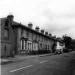
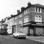
The above photos show, on the left, the west side of Fuller Street (No.s 2-24) in August 1970, not long before demolition. Just visible on the left is the former slaughter house. The right-hand view is of 46 Church Road, at the corner of Fuller Street, still standing in 1976, being passed by an LT Routemaster bus on the 83 route.
The former slaughterhouse at the corner of Fuller St/Chad’s Alley, photographed on 11 December 1971, prior to demolition. Backs of Church Road shop buildings on left.
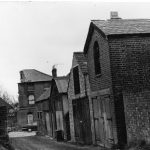
Also taken 11 December 1971, looking down Chad’s Alley, with the photographer’s back to the former Heading Street. Former slaughterhouse at end of alley on right and, beyond that, the part-demolished 3/5 Fuller Street; HADAS’s Fuller St trial trench ran behind these buildings.
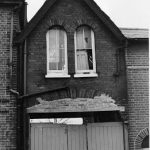
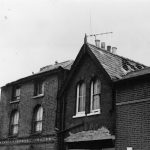
Upper part of No.s 1,3,5 Fuller St, taken 11 December 1971 prior to completion of demolition. Nos 3/5 on right. The Fuller St excavation trench ran behind the site of these buildings three years later. Note distinctive round-headed windows.
close-up of premises seen in previous photo, formerly used by Express Dairies
(11 December 1971)
The re-sited war memorial (seen here in 2012)
The Excavation
This excavation (at approximately NGR ref TQ 23100 89450; Museum of London-issued site code FUL74) followed on immediately from the highly successful Church Terrace dig of 1973/74 a short distance to the west, and preceded total redevelopment of the area of Church End between St Mary’s and Church Road. Directed as ever at that time by Ted Sammes, there was one main trial trench across an area bounded by Church Road to the south, Fuller Street to the west and Sunny Gardens Road to the east, and a smaller trial trench at right angles to this some distance away.
The only published account is a brief mention in the HADAS Newsletters for August and October 1974 and January 1975. It was intended to grid the site on the weekend of 31 August/1 September 1974, with digging to start on the September 1st. A 24-metre long, one metre wide trial trench was cut north-south across the middle of the site. The trench crossed a concrete yard, which was partly removed to permit hand excavation, which normally occurred on Sundays. Newsletter 47, January 1975, recorded that the Fuller Street dig ‘…has proved unrewarding. Neither the objects found, nor the traces of structures such as a gravelled yard and an early pond, merit further work on the site. It has accordingly been discontinued’. The site plan is annotated (some years after the dig, possibly) as ‘Dig stopped when site huts burnt by ‘Kids’? Actually, the huts were left empty on the site after cessation due to its unrewarding nature; the HADAS Research Committee minutes for June 1975 record the destruction by burning of one of the two huts on site, and the resultant loss of tables and chairs.
The main trench ran along the former backyard/garden line of the eastern row of terraced houses along Fuller Street, from behind No.s 52-54 Church Road; it shows the line of their front wall, with an unexcavated gap and then brick footings and features such as WC drain, tile drain and manhole in the trench, in which five one-metre baulks were left.
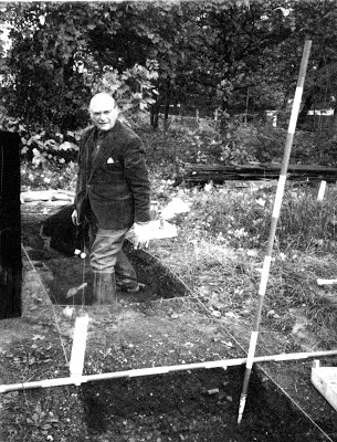
Unlike the White Swan excavation previously recorded by this author, some site records do survive – a single site plan, and just one site photograph, in poor condition, showing long-serving HADAS member, the late George Ingram, standing in a narrow trench amidst the scrub, possibly in the small trial trench, with no features visible.
There are a number of mostly dirty, faded and water-damaged ‘context’ cards with rather minimal information – often just a date, grid number and digger’s name. Only a minority have any information on the nature of the contexts within the grid. There are also brief mentions in contemporary HADAS Committee minutes, which mention ‘the trial trench on this site is extremely disappointing. One area of cobble and gravel has been found [at the northern end of the trench – AS] which will be lifted to see if there is anything under it. Finds made so far do not merit extending the dig’ (15 November 1974) and ‘Work ended on December 15th; the Borough Architect’s Department had not felt that back-filling was necessary. They had kindly agreed to the Society’s huts remaining on the site pro tem’ and there was on-going discussion of the problems finding a new site for the Fuller St war memorial. The contemporary HADAS Research Committee minutes provide further detail, including recording removal of the spoilheap ‘by persons unknown’!
The card for grid A3 – the smaller trial trench – indicates it was dug on 27 October and 16 November 1974, with no features recorded. The photo above by Ted Sammes of the late George Ingram may show this trench. Scanned from a damaged print, it is the only known photo of the actual dig.
The main trench appears to be numbered into six grids, recorded sequentially along the trench as D2 to D7 inclusive, with D2 being ‘550cm to edge of [Church?] Road’.
Grid D2, dug 7th and 14th September, is recorded as containing rubble and garden soil at a depth of 24cm; Grid D3, dug 29 September, contained a disturbed brown layer with rubble at a depth of 17cm; D4 dug 20th October contained mixed soil at a depth of 40-45cm and was heavily disturbed; D5 dug 8 December at a depth of up to 91 cm contained the hard core of a former hard standing at 45cm depth and a field drain, and possibly a Bel larmi ne stoneware sherd; D6, as opposed to the usual two record cards per grid, has six, and was dug between 13 September and 8 December 1974 at a depth up to 1.12m, and contained sand and gravel and gravel and rubble at a depth of 88 to 1.12m overlying a burnt layer at 1.12m down, with a layer of laid pebbles at 50cm depth. Grid D7, dug 16 November, yielded at least one sherd of ‘Mocha Ware’, with gravel, rubble and mixed clay from a depth of 50cm down to the top of a sand layer at 95cm.
The site plan shows the ‘pond’ feature in the end three grids (possibly D5-7), the end one cut by a section bottomed at 1.10m. If the site plan grid references follow the cards, grids D2 and 3 contained brick footings, presumably of the recently demolished terraced houses and their outbuildings; Grid D4 angled brick footings and WC drain; Grid D5 pond, manhole and tile drain (as recorded on the cards) and adjacent granite block, Grid D6 the pond and two tile drains (one a probable continuation of that in D5 the other side of the intervening baulk) along with brick footings; and grid 7 the pond. To be continued, with finds information and analysis
Other Societies’ Events Eric Morgan
Fri 4th May 10.30 am & 12 noon. Friends of Barnet Libraries, South Friern Library, Colney Hatch Lane, N10. The nuts and bolts of local history. Talk with coffee.
Sats 5th , 19th & 26th May Trinity in May. Trinity Church Centre. 15 Nether St. N12 7NN. (Near Arts Depot) Arts, Music & Drama. Email art.sample@gmail.com. Also Finchley Art exhibition 12th – 17th May (Tel: 020 8446 0397)
Sat 5th – Mon 7th May Enfield Archaeological Society. Dig at Theobalds Palace, Cedars Park, Cheshunt, Herts. Volunteers needed for dig to west of great garden wall. Contact Mike Dewbrey 01707 870888 (office) for more details.
Tues 8th May – 5.30 pm . Institute of Archaeology, UCL/British Museum Medieval Seminar. Room 612, 31-34 Gordon Sq. WC1H OPY The Roman–Saxon transition: new evidence from excavations at St.Martin’s-in-the-Fields. Alison Telfer.
Sun 13th – Mon 21st May Barnet Borough Arts Council. The Spires, High St, Barnet. (i nc HA DA S)
Tues 15th May 6.30 pm LAMAS, Clore Learning Centre Mus. of London London Wall EC2Y 5HN The Walbrook: its archaeology and history: a water engineer’s view. Stephen Myers. Visitors £2.00
Wed 16th May – 8.00 pm. Islington Archaeology & History Soc. Islington Town Hall, Upper St. N 1 How archaeology transformed the study of Saxon London. Talk by Bob Cowie (MOLA)
Thur 17th May 6 – 8.00 pm. Friends of Barnet Libraries, Hendon Library, The Burroughs, NW4 4BQ Open evening at Local Studies including tour and presentations.
Fri 18th May 6.30 – 9.00 pm. L.A.A.R.C. Mortimer Wheeler House, 46 Eagle Wharf Rd. N1 7ED. The archaeological archive at twilight. Go behind the scenes to view rarely seen finds. Curator-led tours & object handling. Book in advance £6.00, Concs. £5, Friends £4. On 020 7001 9844 or www.museumoflondon.org.uk/events
Fri 18th May – 7.00 pm. COLAS. St.Olave’s Parish Hall, Mark Lane, EC3. Recent excavations at Holborn Viaduct. Talk by Dave Saxby (MOLA) £2.00
Fri 18th May – 6.00 pm. Museums at night. Islington Museum, 245 St.John St. EC1 V 4N B. Radical Clerkenwell. A brief political history of Clerkenwell Green. Talk by Ben Smith then: 7.00 pm The Marx Memorial Library. Tour by John Callow. Both events are free.
Tues 22nd May – 7.00 pm. The London Archaeologist. Inst. of Archaeology, UCL. Annual lecture & meeting. The archaeology of a Royal Peculiar: new light on Westminster Abbey and its furnishings. Prof. Warwick. Rodwel l. Preceded at 6.30 pm by a wine reception. Free but please RSVP for the reception. becky.wallower@dial.pipex.com
Sat 26th – Sun 27th May 11 am – 4pm. COLAS at the Tower. Foreshore access & public displays. Part of Festival of British Archaeology. Activities in the open space in front of the Tower including handling finds approx. 11 am – 1.00 pm on Saturday and 11.30 am – 1.30 pm on Sunday. http://www.colas.org.uk/documents/COLAS_FBA2012_A5.pdf . Note change of usual date.
Thanks to: Stephen Brunning, Peter Collins, Eric Morgan, Bill Sibley, Andy Simpson.
