No. 542 MAY 2016 Edited by Dot Ravenswood
HADAS DIARY
Lectures are held at Stephens House and Gardens, 17 East End Road, Finchley N3 3QE, starting at 8pm, with tea/coffee and biscuits afterwards. Non-members are welcome (£1). Buses 82, 125, 143, 326 & 460 pass nearby. Finchley Central Station (Northern Line) is a short walk away.
Tuesday 10th May: Hadrian’s Wall; Life on Rome’s Northern Frontier
Lecture by Matthew Symonds
Matthew Symonds is the editor of Current Archaeology magazine and a visiting fellow at Newcastle University. He undertook his doctoral research on Roman fortlet use in the north-western frontier provinces at Christ Church, University of Oxford. Matthew’s research interests include Roman frontiers and Roman Britain, and he has published numerous specialist and popular articles exploring these topics. He is a fellow of the Society of Antiquaries of London, Scotland, and Newcastle, and a regular speaker at archaeological events.
This talk will seek to provide a balanced view of life on Hadrian’s Wall by setting the well-studied military remains within the wider physical and human geography of the frontier zone. It will examine what Hadrian’s Wall was intended to achieve, how successful it was, how it changed over almost three centuries of operation, and what impact the frontier had on the lives lived in its shadow.
Tuesday 14th June, 7.45pm: HADAS ANNUAL GENERAL MEETING, Stephens House and Gardens. Please note the starting time.
Following the meeting, Harvey Sheldon, our President, will give a presentation on the Rose Theatre, “The Rose Discovered and the Rose Revealed,” this year being the 400th anniversary of Shakespeare’s death.
Monday 21st September – Friday 23rd September: HADAS trip to Bradford-on-Avon
Tuesday 11th October: Women in medieval London. Lecture by Professor Caroline Barron
Tuesday 8th November: The Cheapside Hoard. Lecture by Hazel Forsyth.
OUTINGS, OUTINGS, OUTINGS
Outings with Mill Hill Historical Society: HADAS members welcome
Following discussions with Jim Nelhams and Keith Dyall, chairman of MHHS, HADAS members are being invited to partake in their outings. Given that we have no day outings planned for 2016 due to not having anyone to organise them, this is an opportunity to support a fellow local society.
Tuesday 7th June 2016 Rainham Hall
This charming house is one of the country’s finest examples of an early 18th-century merchant’s house. It was opened to the public last October after a £2.5 million conservation project. There are a number of projects planned, especially for the three acres of gardens. The house is furnished with displays relative to its first owner and builder, Captain John Harle. Later it will be altered to suit later owners of the house.
The stables now house the café with an exhibition space above which is regularly changed. Cream teas, cakes, and pre-ordered cold lunches are available. Hot lunches are available from the pub opposite. Captain Harle was buried in the little Norman church next door and we are trying to get the church unlocked for our visit to look inside.
Cost £5 £1 NT The site is within zone 6 for Freedom card holders.
Meet 10.30am Tower Hill Station by the Tram refreshment kiosk.
Tuesday 12th July Bosworth Battlefield Centre.
Finding the remains of Richard III under a Leicester car park and their subsequent re-interment in the Cathedral gives impetus to visit the battlefield site and refresh our memories of events leading up to the battle. There will be a short talk on arrival and a walking tour of the site. There is also the exhibition centre, falconry, an ancient barn converted, into a restaurant/café. 10 minutes away is a heritage railway, a glass blowing centre at the station and a pottery nearby. If we have time there will be a brief visit to the attractive town of Market Bosworth
Cost £28 The coach will leave the Hartley Hall Flower Lane, Mill Hill at 9.00 and leave for home at 4.30. Please book by 18th June 2016.
Saturday 20th August Alresford and Hinton Ampner NT
A visit to the delightful Hampshire town of Alresford. It is well known for being the western terminus of the Watercress Line, and the meeting place for Soviet spies handing over secrets. There are lots of eating places for an early lunch before we move on to Hampton Ampner. In the middle of the 20th century the house suffered a major fire but the owners rebuilt it to how you see it today. It is also well known for its gardens. On the day of our visit there is a traditional jazz trio playing on the lawn from 13.00 until 15.00. This is an interesting place to visit.
Cost £29 NT members £21 The coach will depart from the Hartley Hall, Flower Lane, Mill Hill, at 9.00 and will leave for home at 4.30. Please book by 30th July 2016.
Monday 5th September Holkham Hall
This is one of the great houses of England, on a par with Chatsworth and Blenheim, built by the Coke family between 1734 and 1764. Many of you will remember from your history lessons the agricultural reforms introduced by Coke of Holkham. Besides the magnificent Great House set in a 3000 acre park, there is a museum of agricultural development and a bygones museum as well. The park is home to 800 fallow deer and the lake attracts many hundreds of birds, both resident and on migration. The last Countess developed a pottery within the complex. There is a walled kitchen garden, produce from which can be bought in season.
Cost £36 Historic Houses Association members £25. The coach leaves the Hartley Hall, Flower Lane at 9.00 and leaves for home at 4.30pm. Please book by 6th August 2016. Contact MHHS at 26 Millway Mill Hill, NW7 3RB, tel 020 8959 7147
Tuesday 19th July 2016: Riverside Walk with Blue Badge Guide – Anne-Marie Craven
DOWN BY THE RIVERSIDE or Piety and Piracy
The religious communities in medieval London were a savvy lot. Their monasteries or friaries were ideally located near the water and in this walk we start with the Cistercians near Tower Hill and cross over to what was the Hospital of St Katherine located on the River Thames. It is not long before John Stow in the 16th century christens Wapping Street as a “filthy straight passage” with pubs galore, sailors-cum-pirates, executions and mayhem, a far cry from the tidy converted warehouses of today. We continue, if possible, to Limehouse to see where the Foundation of St Katherine, as it is known today, has its HQ.
We will first walk for 1.5 to 2 hours; it is then intended to adjourn to an Italian restaurant, www.bottegawapping.com recommended by Anne-Marie, for lunch (at your own expense), after which we will continue the walk to Limehouse finishing at around 4pm. You may, of course, drop out at any suitable point along the way.
Please book by Monday 4th July 2016 (please remember to indicate if you are joining us for lunch)
Cost: £12 each plus lunch at your own expense. Minimum number 15/maximum 25
Meet: 10:20 just inside Trinity Square Gardens, by the Tram which sells refreshments, at the exit of Tower Mill Underground Station.
Contact MHHS at 26 Millway Mill Hill, NW7 3RB, tel 020 8959 7147. www.millhill-hs.org.uk/
Excavations at Clitterhouse Farm, Cricklewood by HADAS
Bill Bass and The Fieldwork Team
(Part 2: The Excavations)
Site code: CLM15, Clitterhouse Farm, Claremont Road, Cricklewood, NW2 1PH
NGR: TQ 23689 86819, SMR: 081929, July/August 2015.
For background on this project please see HADAS Newsletter 539, February 2016.
The dig
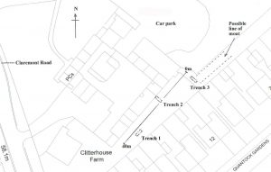 In all, three evaluation trenches of 3x1m were dug over the period of one week, in the narrow enclosed area outside of the south-east main farm building, between the outside of the building and the boundary fence to the gardens of Quantock Gardens. These trenches were essentially trial-trenches just to see what if anything survived, but also positioned to investigate features seen on various archive maps and may give an indication of any archaeological deposits, their survival, and possible dating material. This area appears to be the farm garden from earlier maps, but there is an old ox shed, barn and stable on a different alignment from the main farm complex known from a plan in this area. The southern arm of the “moat” terminates just before this area on known maps, but there are indications that it enclosed a bigger area (say in the Saxon/early medieval period), so there could be a chance of seeing this here.
The parcel of land we were digging had become a bit neglected over the years, and was somewhat overgrown and used as a local dumping ground for builders’ rubble, garden waste and the like. The Clitterhouse Farm Project had the area cleared of overgrowth as best they could; we then laid out a baseline and the trenches. Unfortunately we could not do any resistivity-surveying due to the nature of the ground surface and dumping. A mini-digger machine was used to remove excessive overburden in trenches 2 & 3.
Trench 1
 One of the St Bart’s Hospital Archive maps (SBHB/HC/45/19) of Clitterhouse Farm early in the late 18th century indicates some redevelopment works and buildings to be removed. Some of these works may or may not have taken place, but on the map there is an old structure marked “Barn and Stable requiring repair – but proposed to be taken down”. It was a square shed on a north-south alignment, and the building was demolished as part of the new works not long after the map was made. Trench 1 was placed in the vicinity of these structures.
Removal of the topsoil revealed the edge of some modern concrete slabs to the NE of the trench. In amongst the build-up was a number of car-parts including the wheel centre of a Rover P5 Saloon car, in production 1958-1973. It’s a silvery “Viking” long ship design – they were rovers, hence the emblem. Below the topsoil to the east of the trench, a loose single brick “floor,” unmortared, was laid adjacent to some concrete slabs. This is part of a fairly modern demolished out-building/hard-standing or similar. Below this was a 25cm layer [003] of packed roof tiles and demolition material in a black sandy/silt matrix.This layer appears to slope in to the trench from north to south, possibly from the same building as above.
Below [003] a chalk layer context [007] was uncovered, what appeared to be a beaten chalk floor 5-8cm thick; this covered the whole trench at approximately 57.50m OD. Sealed underneath [007] was an orange/grey sandy clay/pebbly layer context [005] some 14-20cm in depth; there may have been some later intrusion by context [004]. This context also contained some loose large worn cobbles and small amounts of animal bone. The natural London clay was encountered at approximately 57.05 OD.
 Finds from [001] This context included a mixed pottery collection of Post-medieval Redwares (PMR), and more modern whitewares and Transfer-printed wares (TPW) and others. Pottery from [003] contained a variety of fabrics including Tin-glazed Ware A (TPWA), Border Wares (BORD), Post-medieval Redwares, Frechen and Raeren Stonewares.
Trench 1 discussion
The earliest dating material here from layer [005] are 4 sherds of jar-bases of Raeren Stoneware 1480-1610 and 9 sherds of Tin-glazed Ware A 1570-1650. Together with the other pottery mentioned above, we may have occupation say around 1600-1750. Taken together with the cobblestones and animal bone, perhaps we are looking at some of the remains of the “Barn and Stable” and surrounding yard as mentioned on the early 18th century map. Towards the end of the 18th century a chalk floor is laid with occupation in the 19th century, in perhaps more ephemeral “yard” or garden type buildings. Another interpretation is that much of the tile dump [003] resulted from demolition or natural roof-line collapse of the main southern range of farm buildings into the garden, the range which was in great need of repair and rebuilding with a reconfiguration of the farmyard complex and other structures.
Trench 2
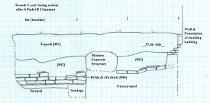
Trench 2, 3x1m, was placed 13.00m east of Trench 1 directly against the wall of the existing southern range of the farm building complex, to see any stratigraphical relationship of the main range to the garden. Up to 50cm of topsoil was removed to expose the main building range foundation, this consisted of a course of stretcher bricks at 57.30 OD, with a course of header bricks directly below, then a further 3 courses of header bricks forming a stepped plinth foundation. In the middle of the trench a large almost ovoid concrete structure appeared running roughly E-W, this may have contained a modern drain or sewer encased in concrete (there was a drain cover nearby), we left it alone and work either side of it.
Below layer [001] the soil changed to become [002], this firm grey/brown silty sandy clay was excavated to a thickness of 55-60cm. Within [002] a brick and tile drain was uncovered, it ran N-S 16cm below the current building foundations. The drain had been laid on a base of tiles with the two sides consisting of 3 courses of brick, fragments of pantile were used to cover the structure. The drain ‘gulley’ was 6cm wide at the northern end, opening out to 16cm wide at the southern end, from here the drain had an easterly curve, some of it may have joined a field-drain system seen in trench 3. The bricks had little or no “frog” and appeared to be reused to form the drain. Natural London Clay was reached at 56.46 OD.
Finds from within the drain and construction ‘cut’ together with the brick (although reused) may give a date of around 1800. The finds from the main [002] layer give a mixed picture, pottery included Transfer Printed Ware 1780-1900, Post-med Redware 1550-1800, White salt-glazed stoneware 1720-1780, Creamware 1740-1830, amongst other small amounts of porcelain and china fabrics. Other finds included two clay-pipe tobacco spurs, one dated 1750-1820 with the initials S & H, the other dated to 1660-1680. Unusually, a pipe-clay “wig-curler” was also recovered. Other material included a small amount of vessel and window glass, iron items – nails, bolts and possible lock-plates, an amount of roof tile and other bits of building material.
Trench 2 discussion
The pantile covered drain may date to the rebuilding of the farm complex sometime in the late 18th – early 19th century, as seen on the SBHB/HC/45/19 map mentioned above. There is then a mixed build-up or silting of material 1800-1900 [002] At some point in the late 19th to early 20th century the main farm building is rebuilt in brick into a dairy farm; this is the “plinth” foundation we can see as it sits on and is dug into the [002] layer.
Trench 3
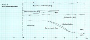 Trench 3, 3x1m, was positioned at the NE end of the excavation area adjacent to the gate and fencing protecting the excavation area. The trench was placed here in an attempt to find possible evidence of the “moat” known to have partly surrounded the farm complex since at least 1584 and most likely well before.
After removing the dumped overburden by machine, a topsoil layer was excavated [003]; below this a firm grey/brown silty sandy clay [005] was uncovered at approx 56.75m OD. This context [005] could be similar to that of [002] in Trench 2, being a firm silty clay layer with little in the way of pebble and other inclusions, but with charcoal flecking, it was homogenous with little in the way of dump or tip layers within. Near the top of [005] a pair of circular field drains (side by side) entered the trench from the SW side; they ended before they reached the NE side. It is tempting to say they were emptying into the “natural” drain that was the silted-up moat, as the fall of the land is in the easterly direction. A sample of [005] was taken for environmental analysis, which is summarised below.
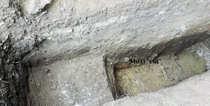
At approx 56.15m OD the context changed to a thin patchy chalky/redeposited clay layer. It was then noted that the change of layer began to dive down towards the SE end of the trench; below all this was the natural London Clay. We recorded this break of slope “a cut feature” from 56.15m to 55.70m OD, at which point the context turned into a black/grey silty layer [007]. It went deeper but at this level became difficult to excavate as we had reached our safety limit and the water-table had been found so the trench bottom kept filling with clear water from a possible spring line or the water-table.
Finds from Trench 3 included from topsoil [003] largely TPW, CREA and others in pottery, various window and vessel glass including a complete Express Dairy milk bottle with printed “College Farm, Finchley”. An amount of iron objects and some building material was also recovered.
From [005] the pottery included a jar rim and two body sherds of medieval South Herts Greyware (SHER) 1170-1350 with flinty inclusions – the oldest pottery recovered from the excavation – PMR, China, TPW and CREA fabrics. A notable and unusual vessel in CREA fabric was the base of a candlestick holder probably dating to 1800-1900. Various amounts of mostly bottle glass with two partial bottles were found dating to the 18th century. There was a miscellaneous collection of building material, not all was kept; a sample of what we processed included brick, peg/slate/pantile, floor tile and sewer-pipe. Other finds seen were more iron items and a small amount of animal bone and oyster shell. A bone knife handle with remains of the iron tang was also found here.
A visiting HADAS member spotted on the Trench 3 spoilheap a shiny object which turned-out to be a gold half-sovereign coin of 1898 in excellent condition. Unfortunately this was “unstratified,” but an interesting item not usually found on HADAS digs!
Trench 3 discussion
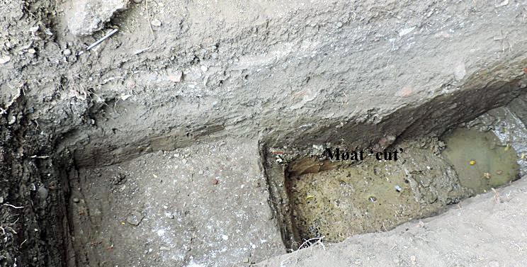
Below the modern topsoil and dumped over-burden we have context [005] which fills the cut “feature”; This feature appears to be the northern slope of a ditch dug into the natural clay, in the position and alignment where we were looking for the “moat”; it would perhaps be a fair assumption that we have found evidence for this feature. Many of the finds from [005] have a wide date range 1170-1900 but possibly most were deposited/dumped approx 1800-1900. It is understood the “moat” was finally backfilled around 1910, but it would seem there was a period of silting beforehand as there were no apparent tip-lines or separate dumping in the [005] fill. In the bottom of the ditch there was a dark-grey black/silty deposit, perhaps some primary silt with some metal-working debris or similar. Iit was difficult to interpret as excavating conditions were a problem in this spot.
Summary
The trial-trenches confirm that archaeological deposits do survive beneath below this parcel of land. From the sealed 17th- 18th century occupation layer in Trench 1 to the brick and tile drain in Trench 2 and moat in trench 3. But there does seem to be a substantial amount of silting-up in trenches 2 & 3 including the filling of the apparent ‘moat’ making interpretation difficult in these areas. They may have been open for some considerable time as part of the farmyard working and later garden use. The presence of the water-table may point to the survival of organic finds in the moat.
From an 1584 map the (excavated) area seems to have been general land in front of and SE of the original timber built farm buildings, there are entrance gates to a field surrounding the moat, another field and a gate to the then extensive woodland to the northern area of the farm. Further maps show the land as a spare or clear area, it then develops into a formally laid-out garden with paths and trees as in an 1816 map. An aerial photograph of 1926 (when the farm was finally closed) still sees it used for gardens. Only the plan showing the proposed works c1790-1816 has a difference as it indicates an “ox shed” and “barn and stables” on this area of land, these are not seen on any other maps (so far) so these buildings may have been a short term measure.
More work needs to be done on the development of the farm and moat plan, through various map and documentary sources. Due to the relative lack of medieval and earlier material in our excavations, preliminary work may indicate that the earlier heart of the farm lies under the present day car-park outside the NE range of the farm building surrounded by the (now filled-in) moat. The documentary sources, possible signs of medieval ridge and furrow from the Cranfield University survey (see part 1) on the playing fields east of the farm and reports of possible ridge and furrow on the Clitterhouse playing field in HADAS newsletter 250, Jan 1992 by Ted Sammes, make it fairly plain there should be medieval occupation evidence nearby.
A later observation
Adjacent to the car-park and roughly 15m NE of the farm building, a concrete base with broken metal ring was found covered-up by grass. This may have been the remains of a barrage balloon mooring-ring dating to the Second World War protecting the Handley Page aircraft factory based on land to the SE, formerly owned by Clitterhouse Farm (Pers. Com A. Simpson).
Acknowledgements and thanks:
Luisa Valejo, Alistair Lamberth & The Clitterhouse Farm Project. HADAS Fieldwork Team – Don Cooper, Vicki Baldwin, Roger Chapman, Tim Curtis, Melvyn Dresner, Eric Morgan, Jim Nelhams, Janet Mortimer, Joseph O’Kane, Sigrid Padel & Andy Simpson. Specialist Reports – Mike Hacker. Jacqui Pearce – selected finds identification.
St Barts Hospital Archive (various maps and documentary sources). Desk-Based Assessment (2008) of the Archaeology and Cultural Heritage on behalf of the Brent Cross Cricklewood Development Partners. Cranfield University – Geophysical Survey of Land at Clitterhouse Playing Field, Jan 2015. Sandy Kidd – Principal Archaeology Advisor (GLAAS) Historic England. Barnet Council Planning Dept.
Appendix 1
Analysis of Environmental Sample, Sample 2a, Trench 3, Context [005] by Mike Hacker, Feb 2016. (This is a summary of Mike’s report, the full report lies with the archive.)
Objective
To assess a soil sample of the fill of a cut feature, believed to be part of a medieval moat, to establish the composition of the fill and the environmental conditions at the time of its deposition.
Location and description of sample
Location: south eastern end of trench 3, depth c. 1m20 below surface level.
Taken from spoil heap c. 24hrs after excavation. (note: possiblity of some contamination from other material on spoil heap). Weight of sample: 1502gm, Condition: damp, Compaction: soft, Colour: dark, brownish grey,
Composition: silty clay. Forms ball and sausage but not ring, Inclusions: occasional pebbles
Processing method
Dispersed in water and repeatedly washed and settled in 15 lt bucket for 60 secs. Supernatant poured over 200µ sieve. Flot retained and air-dried. Residue air-dried. Dried residue swept with ferrite magnet to isolate iron rich particles. Dried residue passed through graded sieves.
Preliminary conclusions
Geology: The relatively high proportion of very fine sand, silt and clay indicates that the bulk of the material is derived from the underlying London Clay bedrock. The London clay does not contain material >250µ and the sand and pebble >250µ isolated from the sample must have been derived from other sources.
Visual observation of sub-rounded to well-rounded flint large pebbles present on the spoil heap and examination of the pebble and sand fractions from the sample suggests that the sand and pebble fractions of the sample is derived from the Dollis Hill gravel. This may be indicative of a head deposit. Alternatively it may be derived from gravel used for roads and paths imported onto the site from the deposits of Dollis Hill gravel on Dollis Hill (c1.5km from the site) or the Hendon plateau (also c1.5km from the site, BGS 1994 1:50,000 Series, North London Solid and Drift Geology, Sheet 258). There is evidence for gravel extraction from both these areas (LB Brent 1988 schedule of archaeological sites, GLHR record No, 1324570 and LB Barnet, Hendon, The Grove, 19thC gravel pit – Proc, Soc Ant. Dec. 1889, p16).
Organic material
The Rubus seed identified is indicative of such plants as blackberry or raspberry. They may have been growing in the ditch fill. However such seeds are very robust and as dietary fruit, they may be indicative of cess deposition. The preliminary identification of seed of Cyperaceae (sedge), a plant associated with damp habitats, would be consistent with it growing in ditch fill. No plant or animal evidence was recovered that would indicate that the ditch was retained standing water at the time the sampled fill was deposited.
Inorganic material
The presence of coal suggests a late medieval or post medieval date for the deposit.
The iron-rich material contained particles of slag and hammer-scale (fig. 3). This is possibly indicative of iron working. However the relatively small proportion of spheroidal hammer-scale suggests low temperature iron working. This would be consistent with activities such as agricultural tool or equipment maintenance or horse shoeing, as opposed to blacksmithing. Alternatively, depending on the date of the deposit, these particles, together with the presence of slag in the other fractions, could indicate material derived from ash from cast-iron hearths.
Potential for pollen analysis
A small sample of the in-situ ditch fill at a depth of c 1.30m below the surface was taken with a hand auger. This has been examined by Prof. Rob Scaife who has confirmed that the deposit contains well-preserved sub-fossil pollen (Scaife R. Pers. Com).
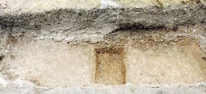
Trench 1 looking north (Melvyn Dresner)
Trench 2 looking West, showing the brick & Tile drain, farm foundations and mystery concrete feature (Melvyn Dresner)
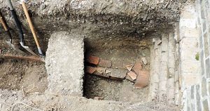 Trench 3 looking east including the moat cut into natural clay (Melvyn Dresner)
Desmond Collins by Don Cooper
 It is with sadness that we report the death of Desmond Collins on the 9th March 2016. Desmond had a long and close association with HADAS. He taught archaeology at the Hampstead Institute and the UCL Institute of Archaeology, and was a contributor to several publications. He was especially interested in the evolution of early man and the development of culture. He jointly directed the excavations on West Heath in the 1970s. The results of the excavation were published under his and Daphne Lorimer’s editorship as “Excavations at the Mesolithic Site on West Heath Hampstead 1976-1981”. It was a BAR British Series 217 (1989) publication.
As Brian Jarman’s foreword to the book sums it up:
“The Hendon & District Archaeological Society wishes to express the big debt of gratitude it owes to Desmond Collins, who gave of his time and expertise to direct the West Heath excavations. With unfailing patience, he taught the skills necessary to excavate the site, encouraged members to follow their own lines of research and contributed in great measure to the success and enjoyment of the dig.”
Desmond was a life member of HADAS. His friends in HADAS would like to extend our deepest sympathy to Ann, his wife, and all his family. With thanks to Myfanwy Stewart for her contribution.
Other Societies’ Events Eric Morgan
Wednesday 4th May 6pm The Princes Alice Disaster Docklands History Group. Talk by John Lock. Museum of London Docklands No. 1 Warehouse, West India Quay, Hertsmere Rd, Canary Wharf E14 4HL. Visitors £2.
Saturday 7th May 10.30-5.30pm Before the Doors: London River and the Port in the 18th Century Docklands History Group 5th Annual Symposium. Museum of London Docklands No. 1 Warehouse, West India Quay, Hertsmere Rd, Canary Wharf E14 4HL. Information and booking: www.docklandshistorygroup.org.uk .
Wednesday 18th May 7.30pm Agincourt at the Islington Borders, Whitsun 1416. Islington Archaelogical & History Society. Talk by Lester Hillman, on echoes of Agincourt from Moorgate’s archery heritage to Dick Whittington’s stone on Highgate Hill. Visitors £1.
Wednesday 1st June 6pm London’s Great Fire and its Aftermath Talk by Dr Stephen Porter (Charterhouse archivist). Gresham College at the Museum of London (MoL), London Wall, EC2Y 5HN. Free.
Saturday 4th June 10.-30am-4.30pm.Local History Day British Association for Local History. St Andrew’s, Holborn, EC4A 3AB. A range of interesting sessions. Information/booking: www.balh.org.uk/events
Thursday 9th June 7.30pm From Forty Hill to Bulls Cross Illustrated talk by Frank Bayford, preceded by AGM & refreshments. Enfield Society, Jubilee Hall, 2 Parsonage Lane, jncn Chase Side, Enfield EN2 0AJ.
Friday 10th June 7.30 for 7.45pm Poet’s Corner Yard Dig, Westminster Abbey Enfield Archaeological Society. Talk by Chris Mayo (PCA) . Jubilee Hall (see May 9). Visitors £1. Refreshments.
Sunday 12th June Tea in the Park with Barnet Museum and Local History Society. The park is behind the museum, Wood St, Barnet. Includes musical events and fine teas.
Monday 15th June 3pm Another Look at Postcards Talk by Terence Atkins. Barnet Local History Society, Church House, Wood St, Barnet (opp. Museum).
Friday 17th June 7pm A Pilgrim’s Progress: Recreating a 14th Century Journey Talk by Steven Payne. COLAS, St Olave’s Parish Hall, Mark Lane EC3R 7LQ. Visitors £2.
Friday 17th June 7.30pm The French Navy During WWI Talk by Malcolm Barres-Baker. embley History Society, English Martyrs’ Hall, Chalk Hill Rd, Wembley HA9 9EW. Visitors £3.
Saturday 18th & Sunday 19th June London Open Garden Squares Weekend Visit gardens not normally open to the public (more than 200). Organized by London Parks and Gardens Trust and the National Trust. Including 10am-5pm Myddelton House Gardens (where HADAS has done a resistivity survey). For details see www.opensquares.org .
Sunday 26th June 11am-5pm Steam Open Day Markfield Beam Engine Museum, Markfield Park, Markfield Rd, South Tottenham N15 4AB. Free admission.
Thursday 30th June 7.30 for 8pm AGM, followed by: A Dip into the Archives Finchley Society, Drawing Room, Avenue (Stephen’s) House (address, see front page). Non-members £2, refreshments before and after.
_______________________________________________________________________________
With thanks to this month’s contributors: Bill Bass, Don Cooper, Eric Morgan
_________________________________________________________________________________
